Walks
Since 2015, I’ve been going on long walks. It’s the most interesting way I’ve ever spent my time, even if walking for an extended period is dangerously addictive (if not as harmful as heroin, carbohydrates, and a monthly salary).
Most of my long walks to date have been in Japan, but I’ve also walked in Iran, Iraqi Kurdistan, Hungary, Serbia, and Croatia. My walk across the island of Shikoku, in Japan, formed the basis of my first book, The Wilds of Shikoku.
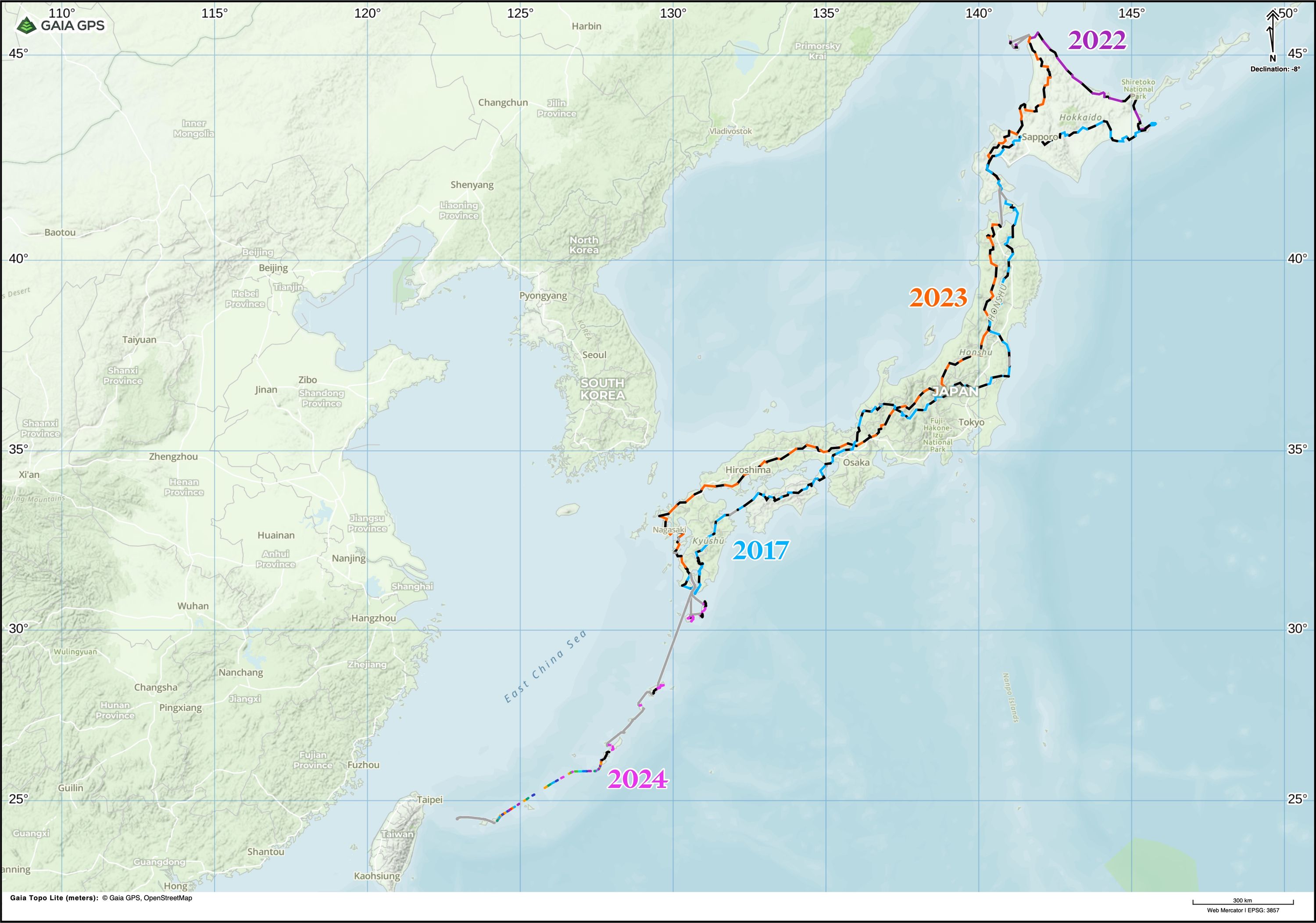
This page lists all my walks longer than ~100 kilometers, and provides overview maps, basic time/distance data, and links to the field diaries I kept on some of them.
Last update: March 15, 2025
Around Japan 4/4: Kagoshima to Yonaguni (2024)
- Start: April 3, 2024 – Kagoshima City
- Finish: May 1, 2024 – Cape Irizaki, Yonaguni, Okinawa
- Distance: ~500 kilometers
The fourth and last stage of my walk around Japan, starting three months after I arrived back in Kagoshima (see below for parts 1–3). I was joined by my wife Natalie Kallay and also, briefly, by my brother Gabor Orosz, who became the only person to join me on every part of this journey. Together, we walked across or around seven islands between the Japanese mainland and Taiwan: Tanegashima, Yakushima, Amami-Ōshima, Tokunoshima, Okinawa, Ishigaki, and Yonaguni. The rest of the journey — much longer — was on ferries, except between Okinawa and Ishigaki, where the only option was to fly.
From March to June 2025, I’m an artist in residence at Tenjinyama Art Studio in Sapporo, Japan, where I’m writing Data Reduction 9K, a blog about figuring out whether the walk was interesting enough for a book. Sign up here to get an email when I write a new post:
A blog about Peter Orosz’s 9,000-kilometer walk around Japan.
Around Japan 3/4: Wakkanai to Kagoshima (2023)
- Start: September 15, 2023 – Wakkanai, Hokkaido
- Finish: January 6, 2024 – Kagoshima City
- Distance: ~3,500 kilometers
The third part of my walk around Japan, starting on the next calendar day and from the same place where I finished in 2022. For some days, I was joined on this journey by my friends Agnes Tandler, Simon Herzog, and Gyula Simonyi, and for two weeks by my brother Gabor. See below for parts 1–2. After a three-month break, I returned to Kagoshima with my wife Natalie, and we continued together until we reached Yonaguni, the westernmost end of Japan.
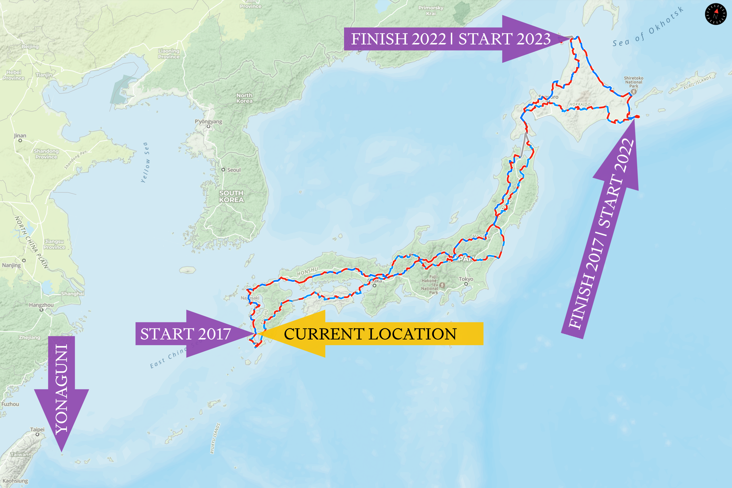
Around Japan 2/4: Nemuro to Wakkanai (2022)
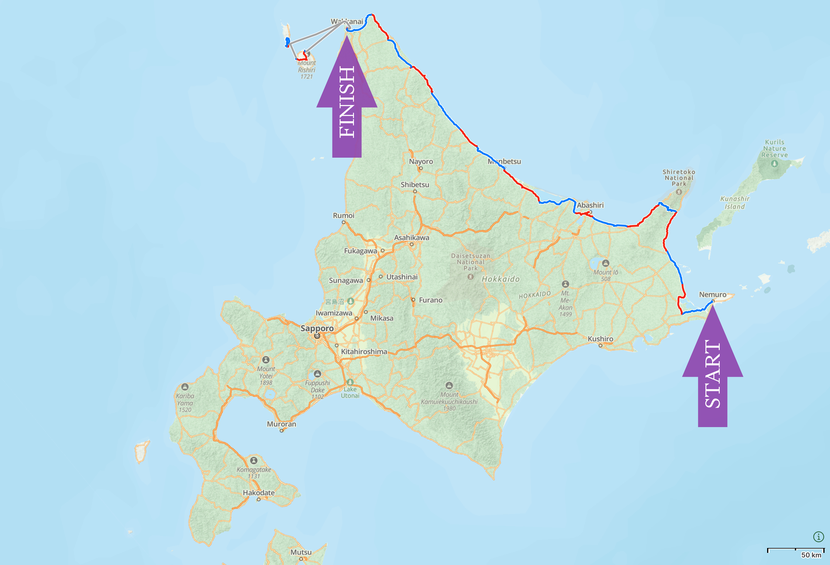
- Start: August 22, 2022 – Nemuro, Hokkaido
- Finish: September 14, 2022 – Wakkanai, Hokkaido
- Distance: ~640 kilometers
The second part of my walk around Japan, starting on the next calendar day and from the same place where I finished in 2017 (see below for the first part). Human Again, a series of three illustrated dispatches I wrote on the road, is about this journey.
My brother Gabor joined me until we reached Abashiri on the Sea of Okhotsk. From there, I walked on alone until Cape Sōya, the northernmost point of the Japanese mainland, then Wakkanai and its outlying islands, which I also crossed.
Exactly a year later I returned to Wakkanai and continued from there on the next calendar day (part 3).
Chūgoku (Western Honshu), Japan (2019)
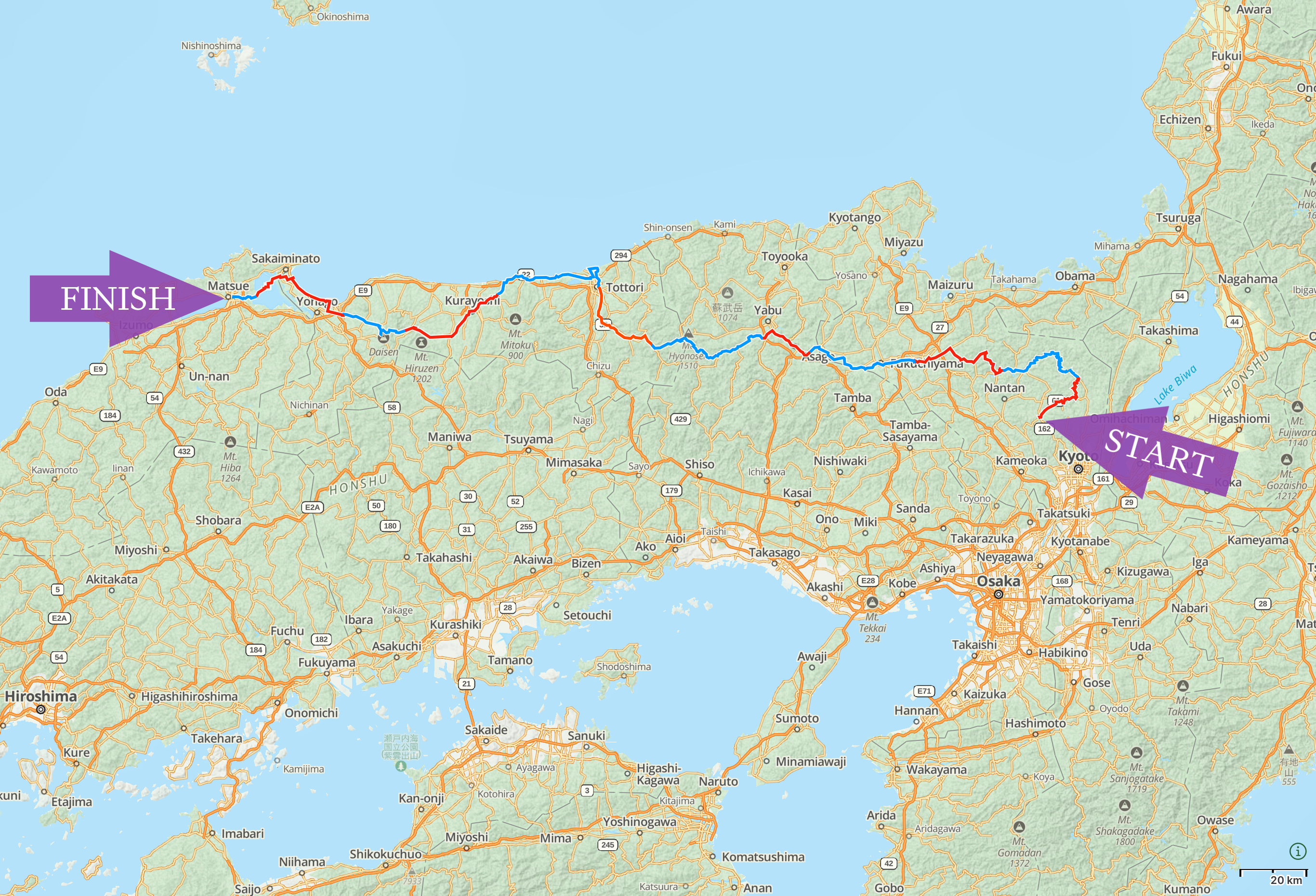
- Start: October 30, 2019 – Shūzan, Ukyō Ward, Kyōto
- Finish: November 10, 2019 – Matsue, Shimane
- Distance: ~420 kilometers
An autumn walk across the prefectures of Kyōto, Hyōgo, Tottori, and a corner of Matsue; about half of the region called Chūgoku, which is the part of Honshu west of Osaka and Kyōto. Along the way I traversed three mountains, one of them volcano Daisen, the highest point of the region.
Shikoku, Japan (2019)
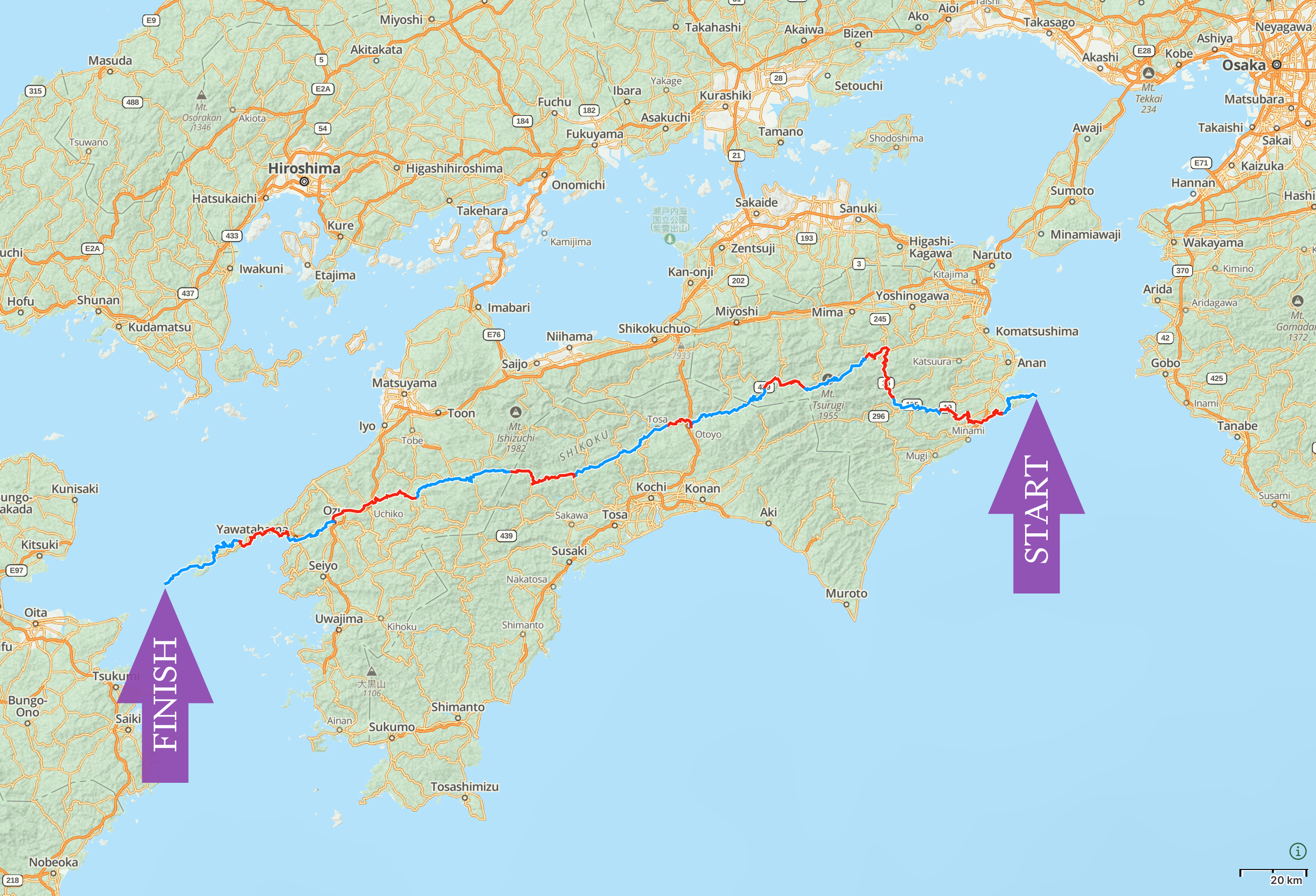
- Start: January 24, 2019 – Cape Kamoda, the easternmost point of Shikoku
- Finish: February 8, 2019 – Cape Sada, the westernmost point of Shikoku
- Distance: ~500 kilometers
A winter walk across the smallest of Japan’s four main islands that became the subject of The Wilds of Shikoku, my first book. You can also read a day-to-day account of this journey in the field diary that I kept while I walked.
I followed in the footsteps of Alan Booth, the English author of The Roads to Sata and Looking for the Lost, who had walked across Shikoku 36 years earlier, in May and June 19831.
The journey and the subsequent production of the book was financially supported by an Indiegogo campaign in December 2018.
My friend Gyula Simonyi accompanied me halfway across the island. From there, I walked on alone to the lighthouse at Cape Sada, the westernmost point of Shikoku.
Around Japan 1/4: Kagoshima to Nemuro (2017)
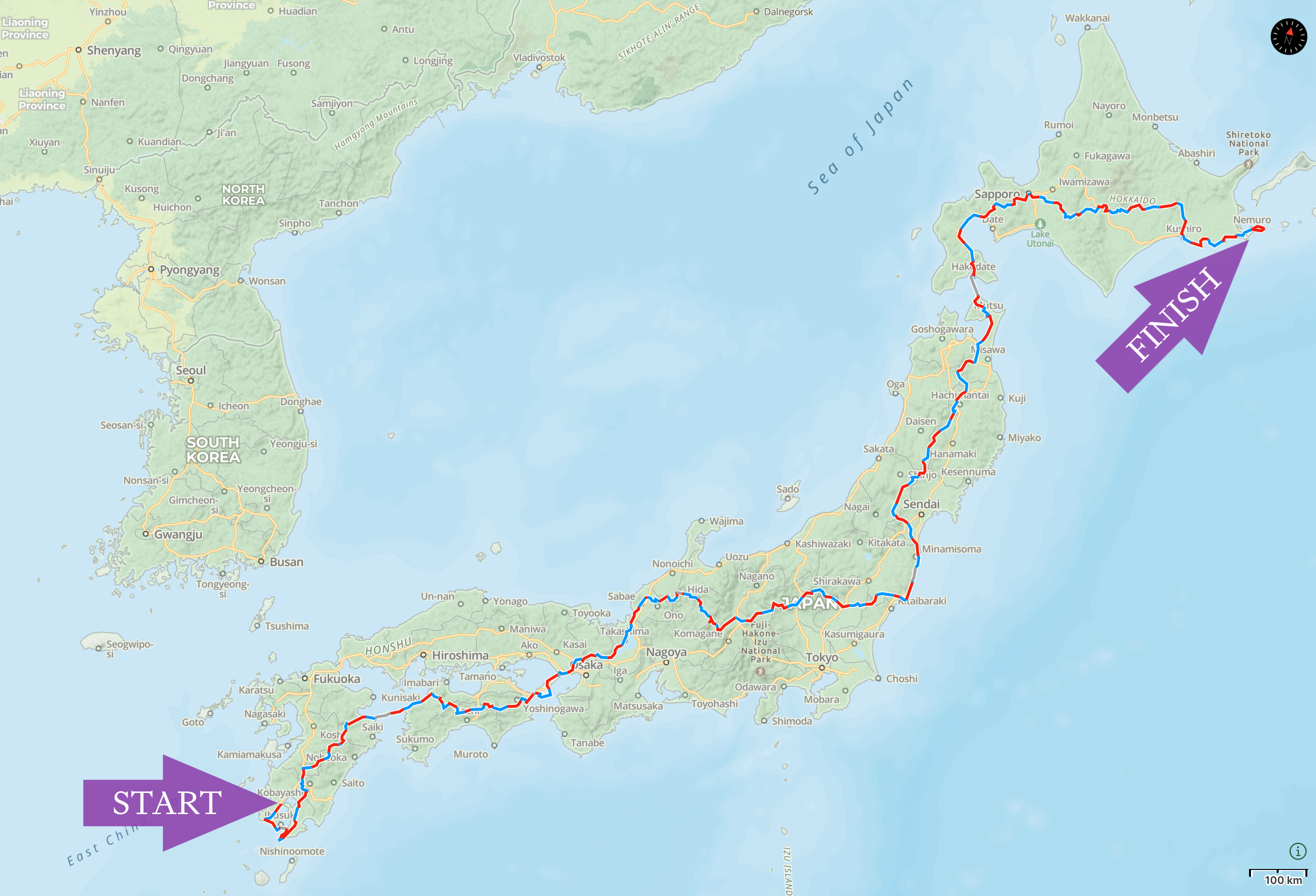
- Start: April 13, 2017 – Kagoshima City
- Finish: August 21, 2017 – Nemuro, Hokkaido
- Distance: ~4,100 kilometers
The first part of my walk around Japan, and my longest walk to date. I wrote extensively about this journey in These Walking Dreams, the field diary I kept on the road.
I began walking in Kagoshima, on Kyushu, the southernmost main island. In April and May I crossed Kyushu, then Shikoku, the smallest of the main islands, and arrived on Honshu, the largest, on May 24. In the next two months I crossed three of Honshu’s five regions: Kansai (South-Central Honshu), Chūbu (Central Honshu), and Tōhoku (Northeast Honshu).
On July 24 I arrived in Hakodate, in the south of Hokkaido, the northernmost main island, where Gabor, my brother, joined me. Together, we walked across Hokkaido and reached Cape Nosappu, the easternmost point of the island and also of the Japanese mainland, on August 21.
Five years later, in August 2022, we returned to the same spot on the next calendar day and walked on, a journey I wrote about in Human Again.
Iranian and Iraqi Kurdistan (2016)
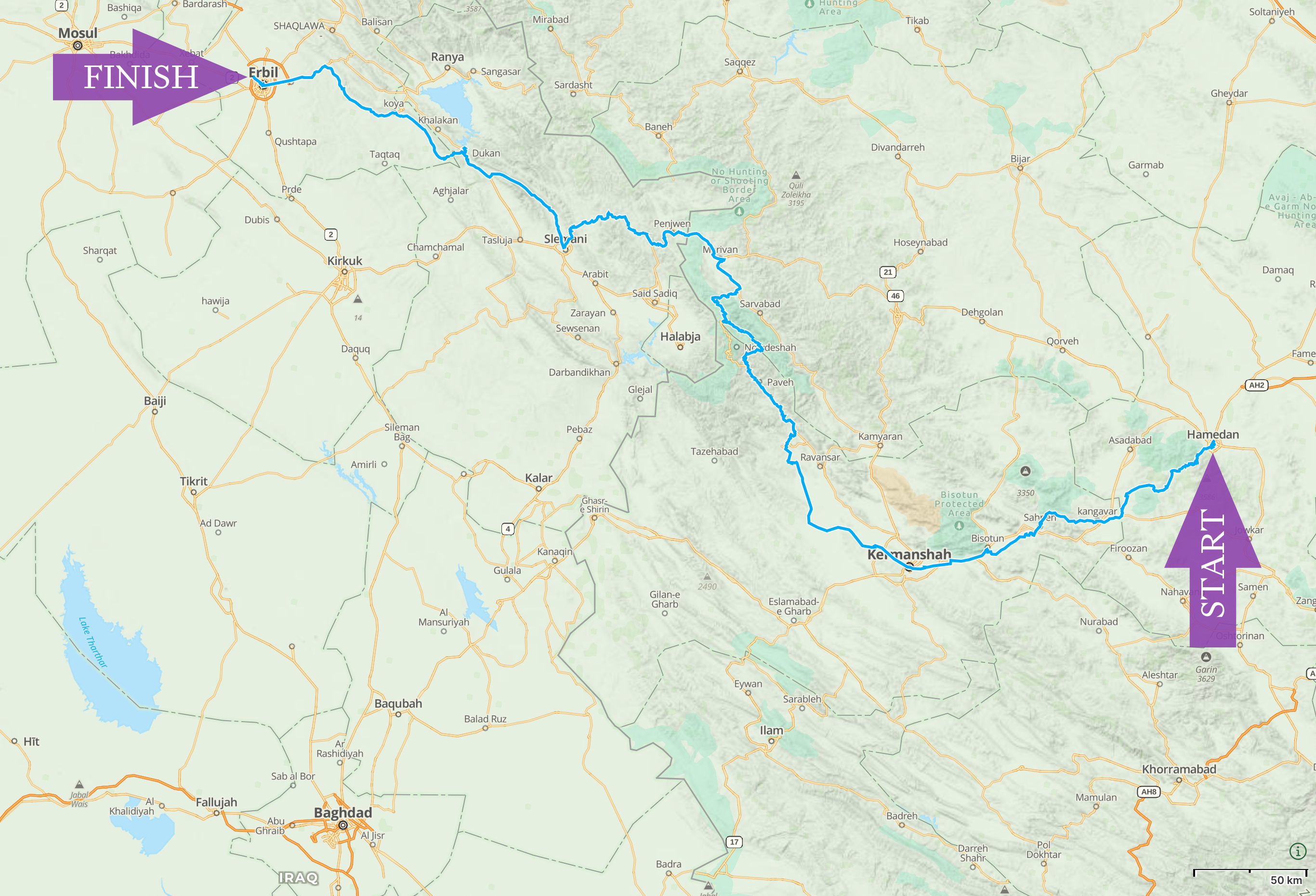
- Start: April 30, 2016 – Hamadan, Iran
- Finish: May 25, 2016 – Erbil, Iraqi Kurdistan
- Distance: ~800 kilometers
A late spring walk across the Zagros Mountains, which separate the high plateau of Iran from the lowlands of Iraq. My journey was mostly across the Iranian and Iraqi parts of Kurdistan — Rojhelat and Rojava, respectively — a region that also spans adjoining regions of Syria and Turkey.
I posted some pictures from this walk in my photo diary of Iran and Iraqi Kurdistan, which also has pictures from a family holiday in other parts of Iran.
South Kyushu, Japan (2015)
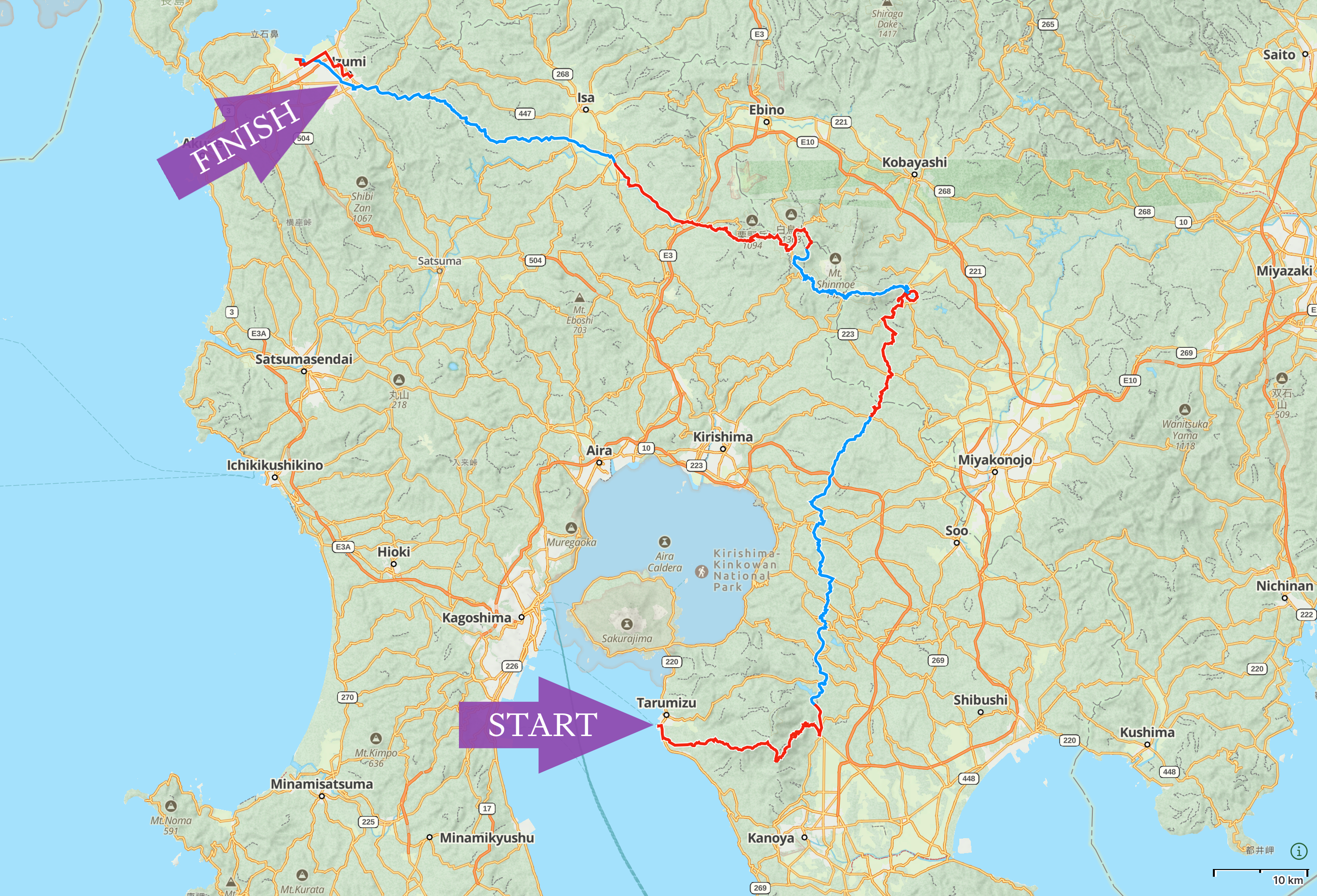
- Start: December 7, 2015 – Tarumizu, Kagoshima
- Finish: December 14, 2015 – Izumi, Kagoshima
- Distance: ~210 kilometers
An early winter walk across some remote areas of southern Kyushu. After taking a ferry from Kagoshima to Tarumizu, I traversed Mount Takakuma, turned north, traversed the Kirishima volcanoes, then walked to Izumi on the shore of Minamata Bay, the wintering site of large populations of white-naped crane (Antigone vipio) and hooded crane (Grus monacha).
Yakushima, Japan (2015)
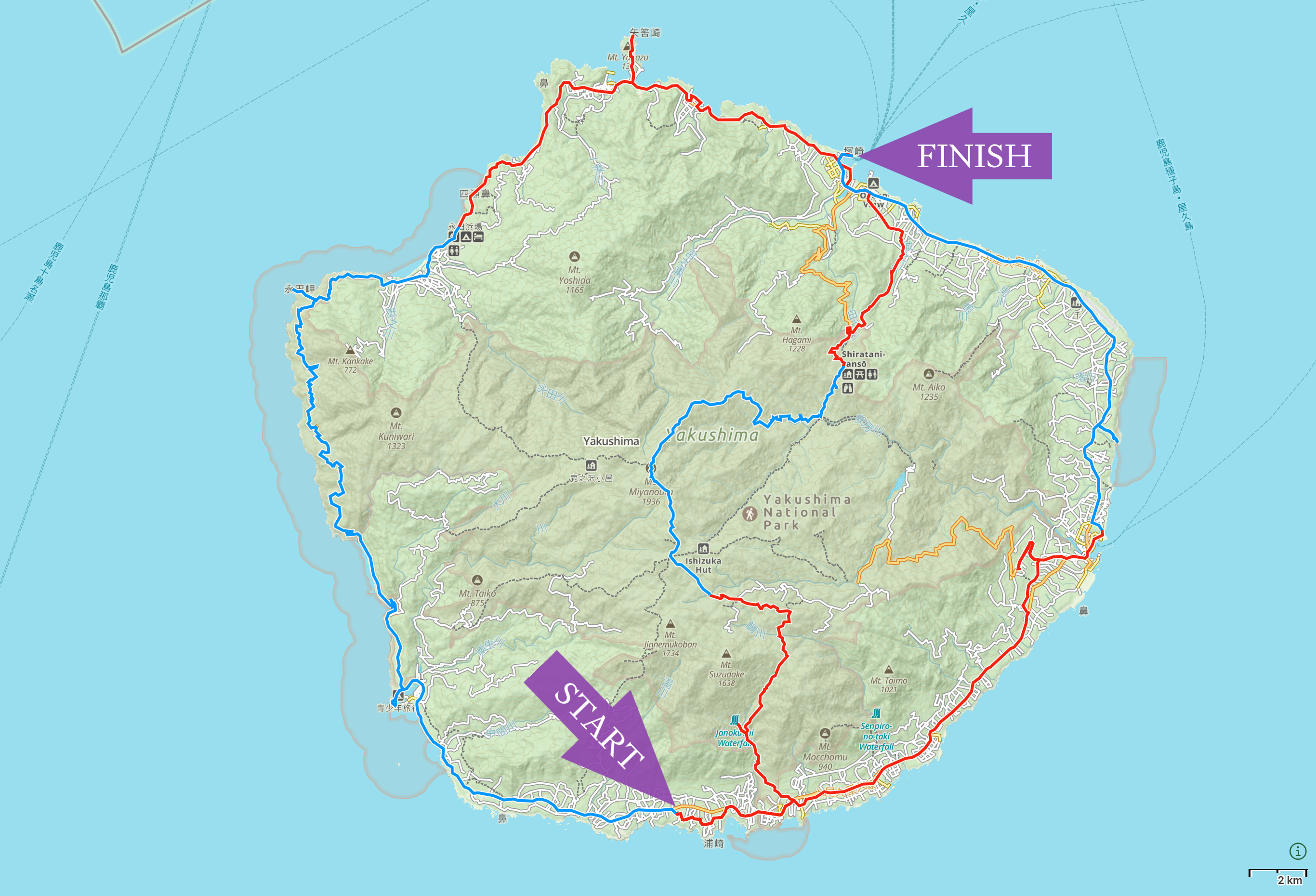
- Start: October 16, 2015 – Hirauchi, Yakushima
- Finish: October 22, 2015 – Miyanoura, Yakushima
- Distance: ~160 kilometers
My first walk in Japan, but the idea was my brother Gabor’s, who was living in Kagoshima at the time, near the southern tip of the Japanese mainland, from where we took the ferry Yaku-2 to Yakushima.
We began walking on the south coast and walked across Yakushima’s mountainous interior, touching the summit of Mount Miyanoura (1,936 m), the highest point of the island, then walked down to the north-eastern coast. From there, Gabor took a ferry back home to Kagoshima and I walked counter-clockwise around the island on my own.
Hungary–Serbia–Croatia borderlands (2015)
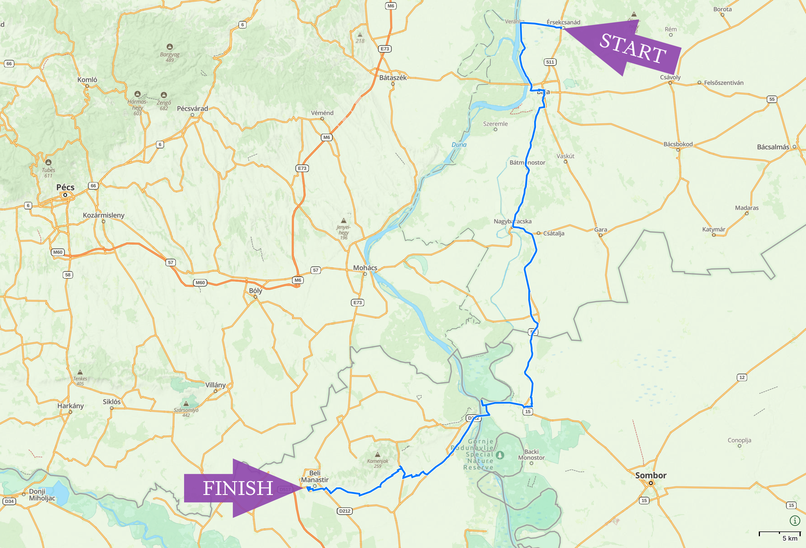
- Start: September 10, 2015 – Érsekcsanád, Hungary
- Finish: September 13, 2015 – Beli Manastir, Croatia
- Distance: ~100 kilometers
A late summer walk with my wife Natalie, to document the fish soups of the Danube borderlands. An account of our journey, Hungary’s Fish Soup Masters, was published by Roads & Kingdoms in October 2015.
We started near my family’s summer house in southern Hungary, walked south across the Serbian border, then west across the Croatian border, then to the ethnic Hungarian village of Sepse (Kotlina on international maps, Sepse is its Hungarian name), my father’s birthplace. Along the way, we sampled the fish soups of Rév Csárda in Hungary, Pikec Čarda in Serbia, and Kovač Čarda in Croatia.
Transdanubia, Hungary (2015)
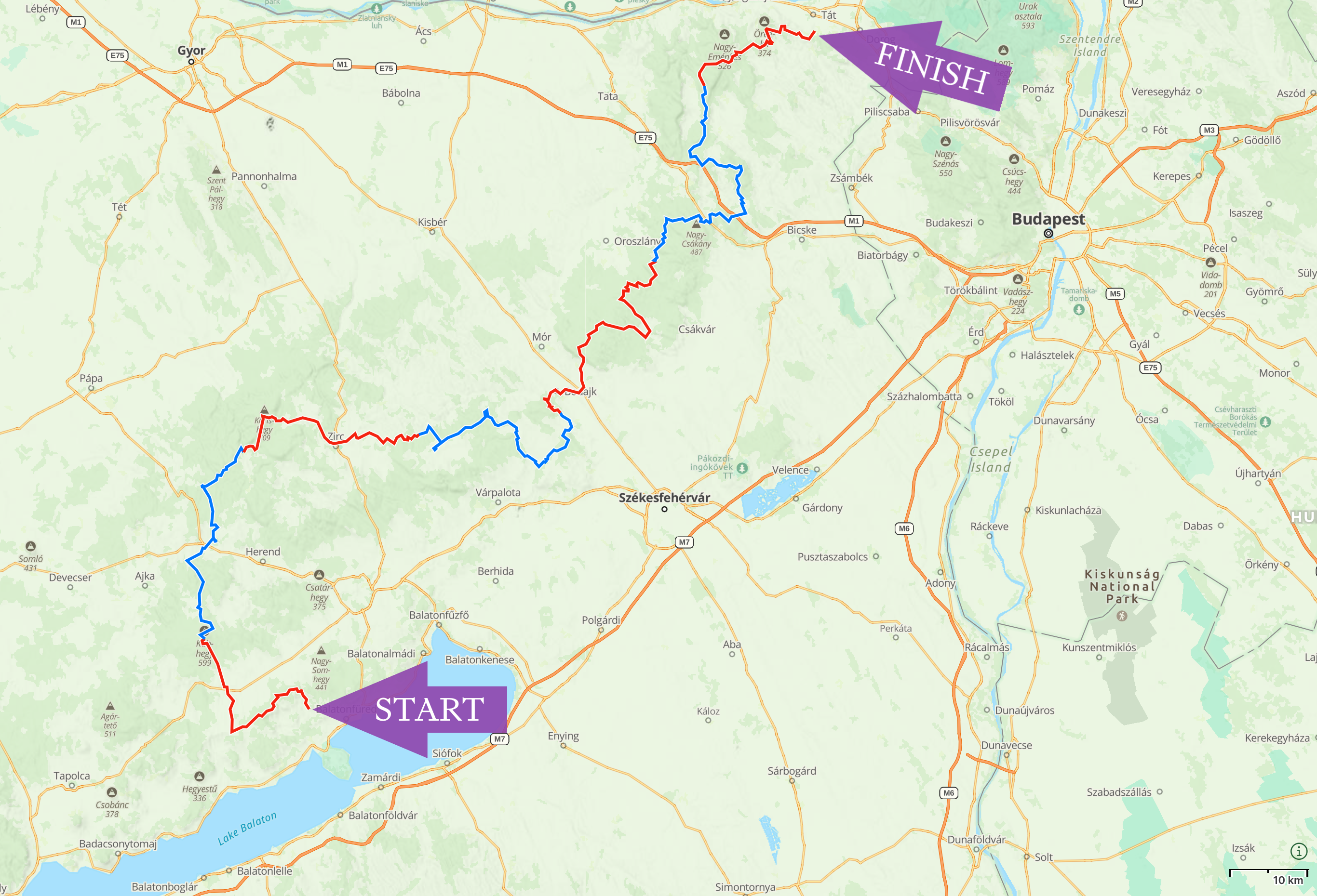
- Start: July 23, 2015 – Balatonszőlős, Hungary
- Finish: July 29, 2015 – Tokod, Hungary
- Distance: ~270 kilometers
A walk in the high summer across the hills of Western Hungary.
My friend Ferenc David Marko joined me for the first day as we walked from his brother’s summer house to the village of Mencshely. From there, I walked on alone, largely following the route of the National Blue Trail.
Booth’s account of his own journey, “Roads Out of Time”, was published in the posthumous anthology This Great Stage of Fools. I used the book to reconstruct his route.↩︎