These Walking Dreams
These Walking Dreams is a field diary I kept on a 4,100-kilometer walk from one end of Japan to the other, in the spring and summer of 2017.
Learn more about this project at /japan
It was originally published on Instagram under #roadsfromsata, where I continually posted pictures while I was on the road, accompanied by entries on what I had seen, experienced, and felt.
The diary is republished here in expanded and revised form, with more photos, improved maps, and slightly retouched entries.
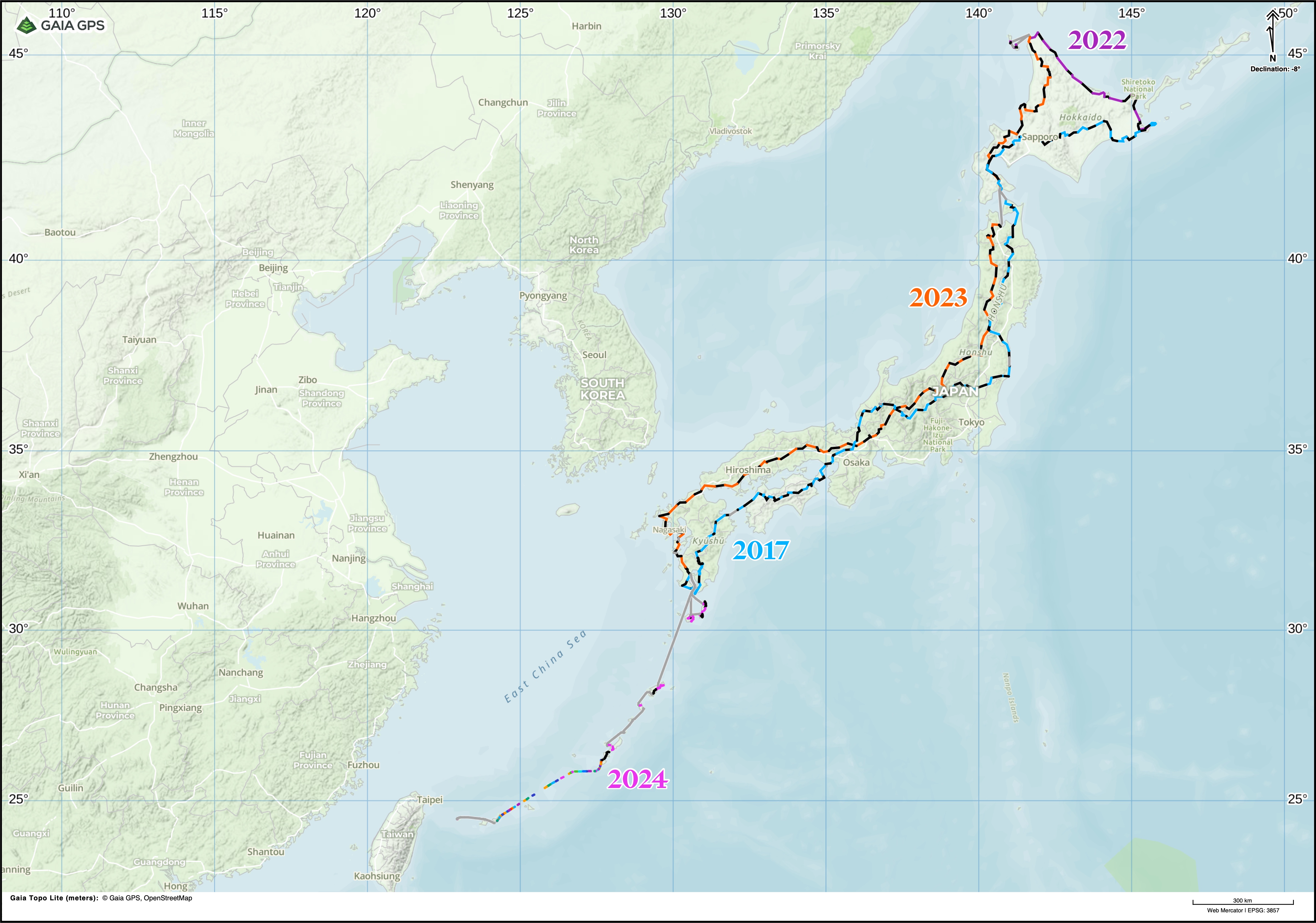
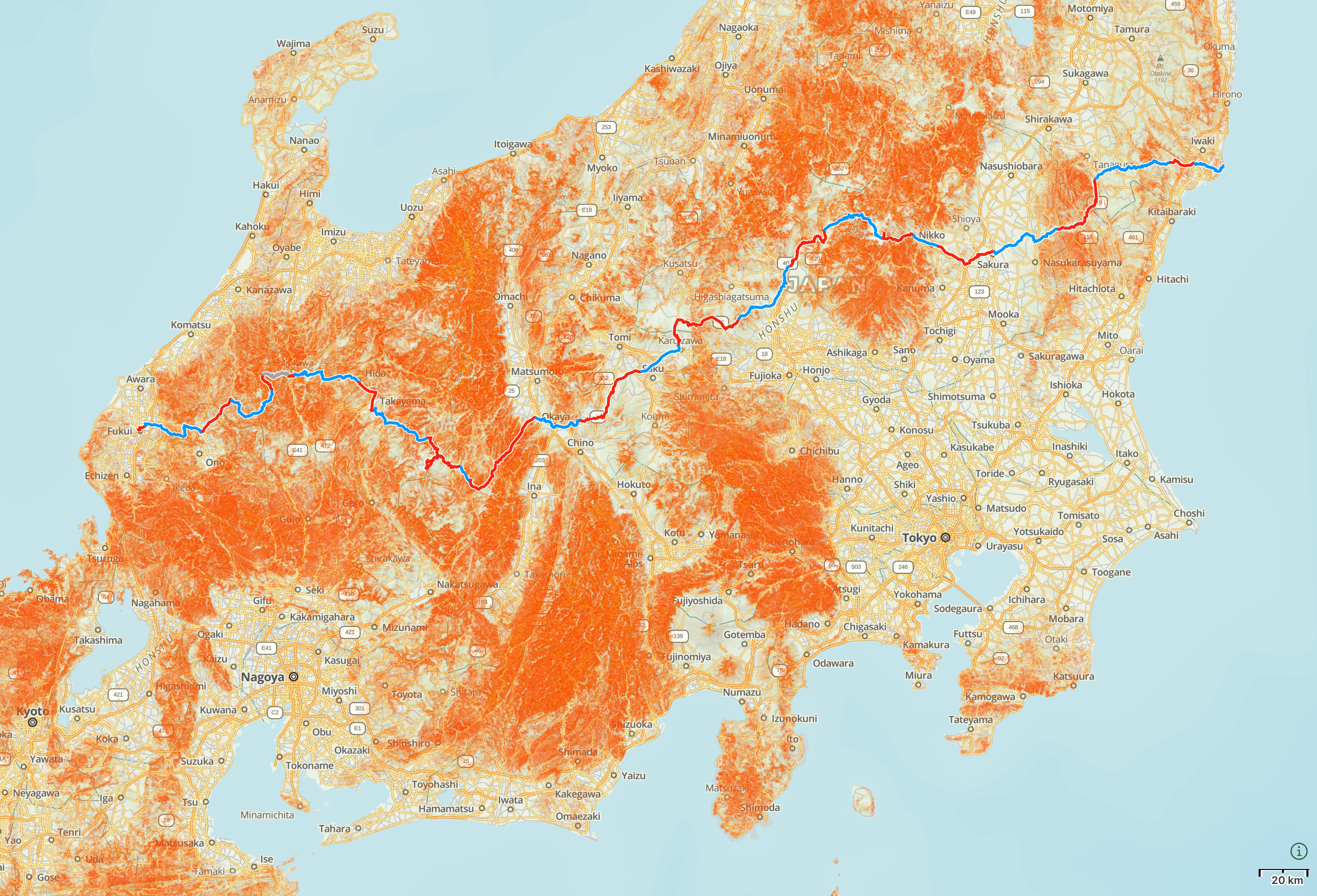
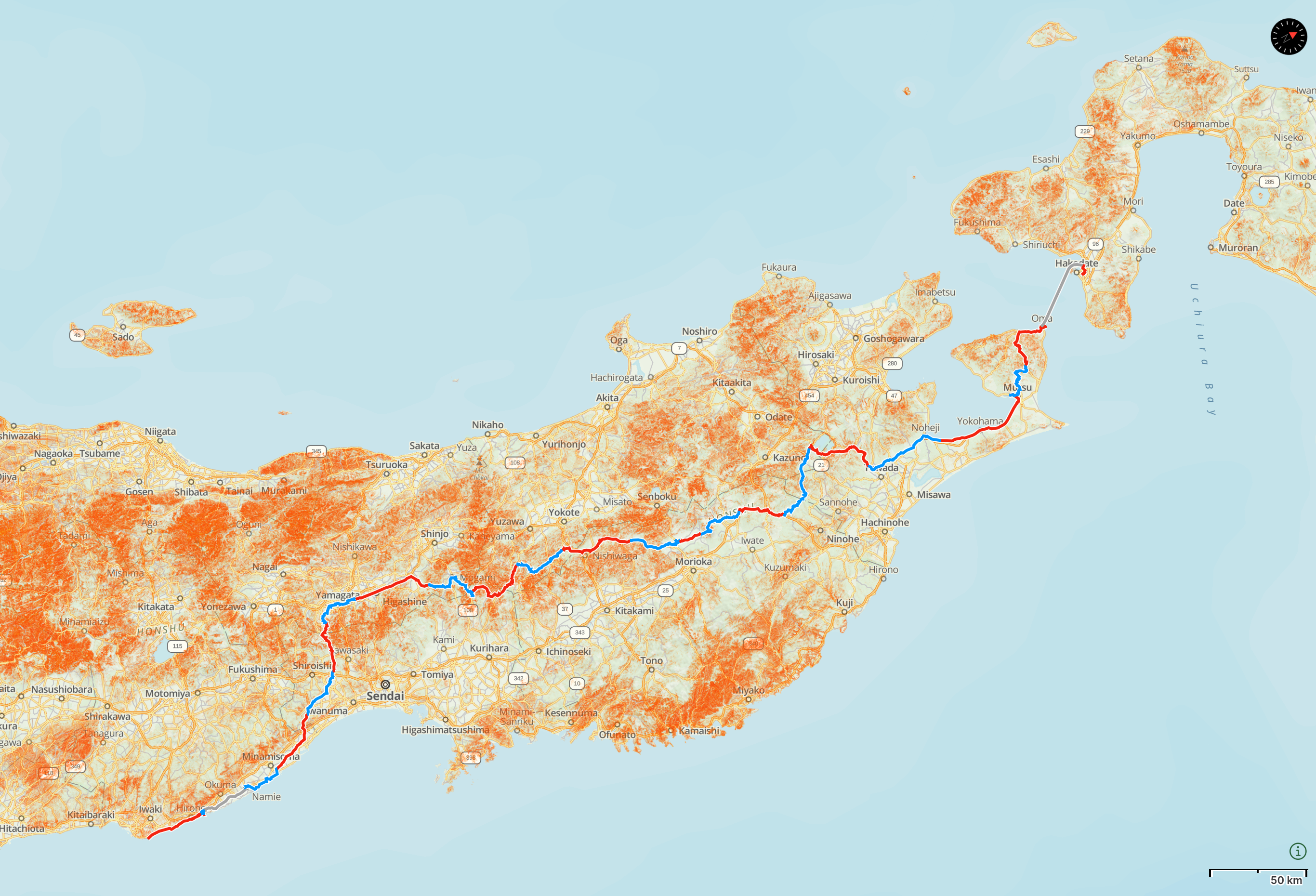
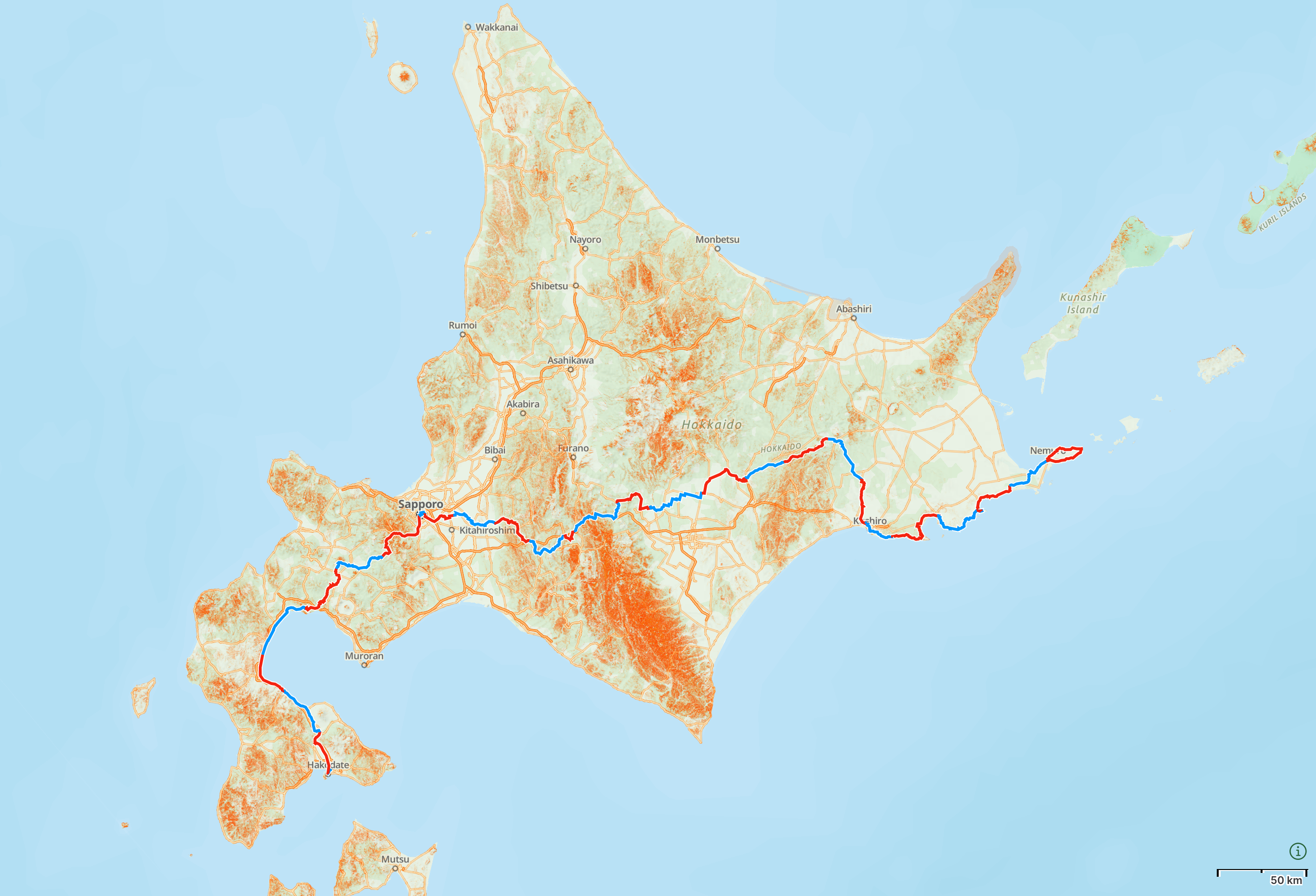
My route across Japan
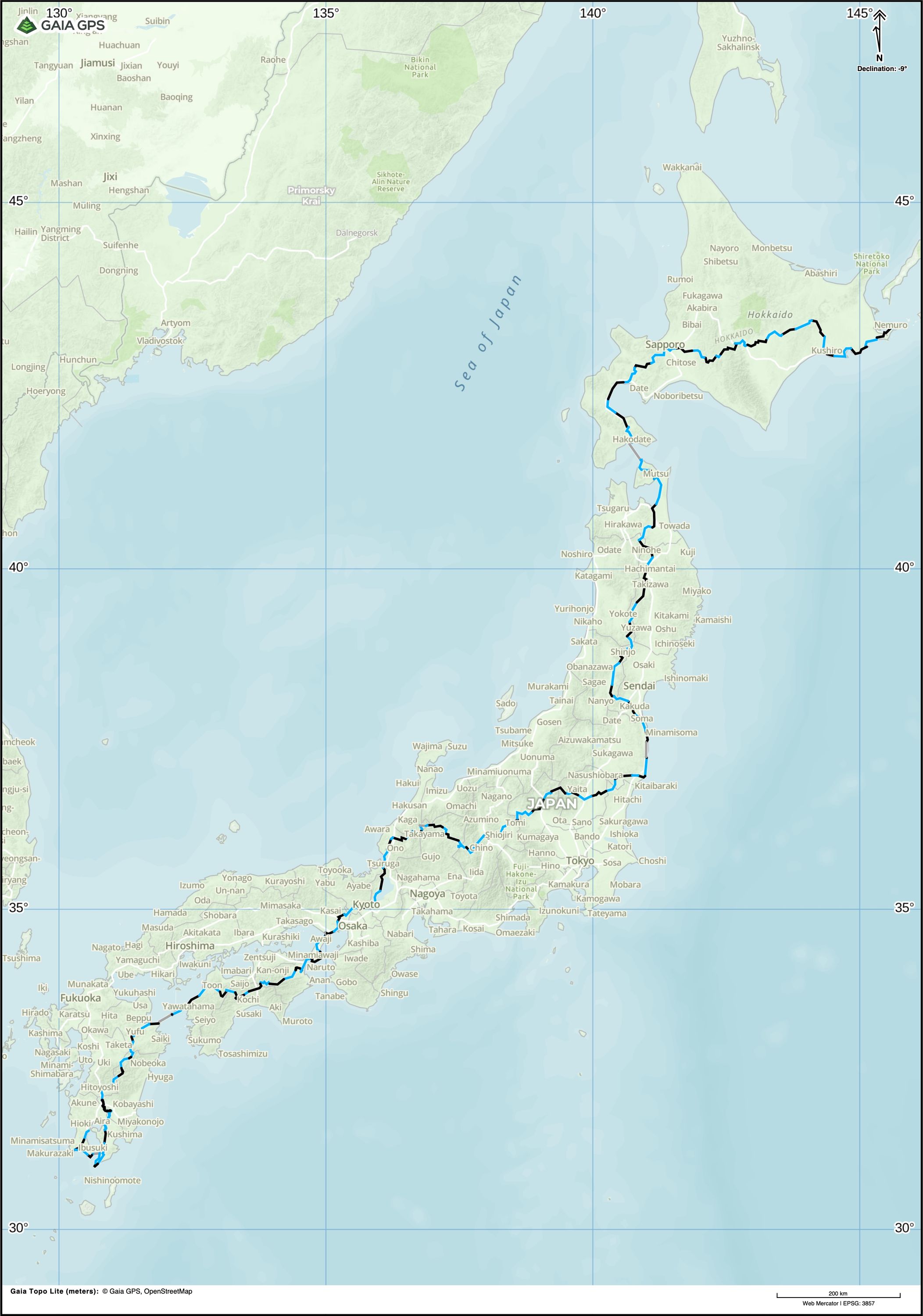
Except for four ferry crossings, two toll roads, and one nuclear exclusion zone1 — marked in grey on the map above — I walked every step of the way.
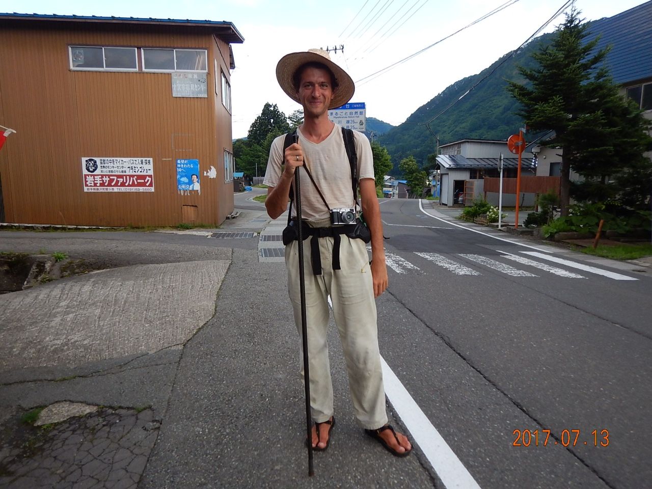
I began walking in Kagoshima City, in the south of Kyushu, the southernmost of Japan’s four main islands, on the morning of April 13, 2017. In April and May I crossed Kyushu, then Shikoku, the smallest of the main islands, and arrived on Honshu, the largest, on May 24. In the next two months I crossed three of Honshu’s five regions: Kansai (South-Central Honshu), Chūbu (Central Honshu), and Tōhoku (Northeast Honshu).
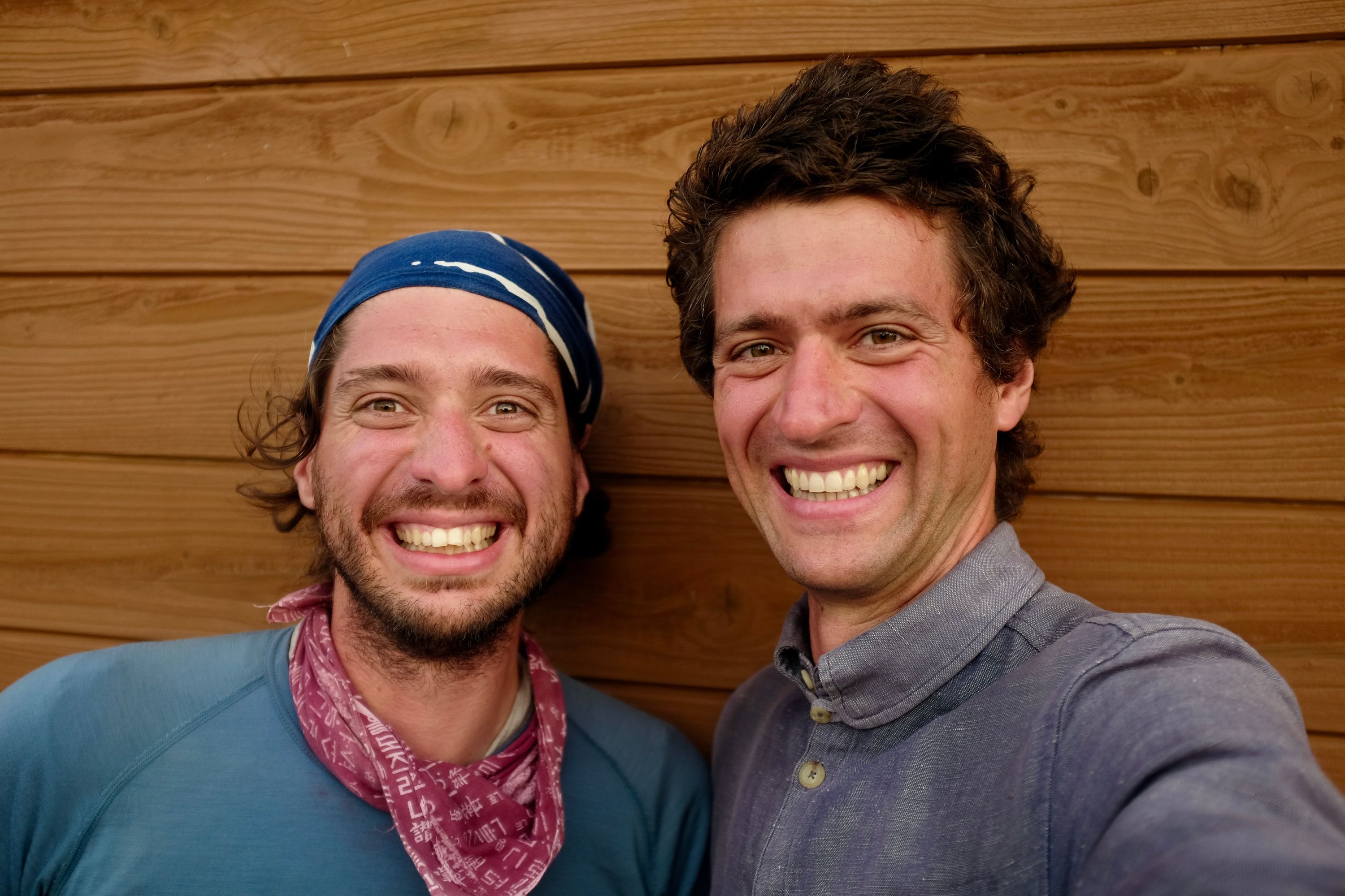
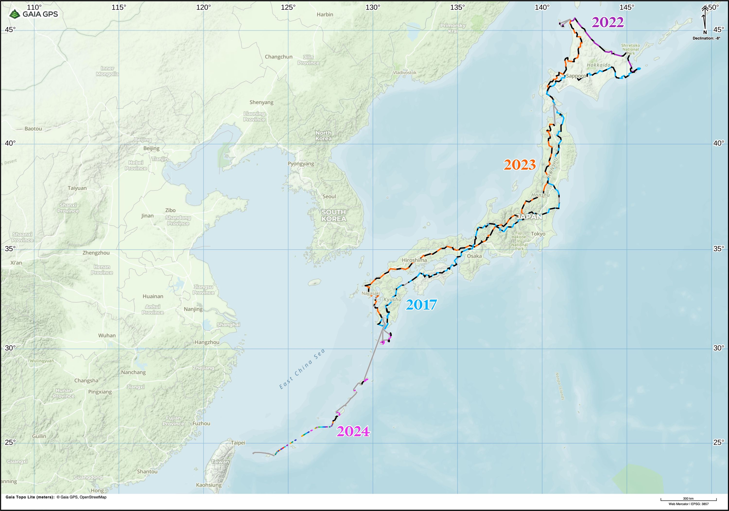
On July 24 I arrived in Hakodate, in the south of Hokkaido, the northernmost main island, where my brother, Gabor Orosz, joined me. Together, we walked across Hokkaido and reached Cape Nosappu, the easternmost point of the Japanese mainland, on August 212.
Five years later, on August 22, 2022, we continued our journey from the same spot. Gabor walked with me until we reached Abashiri, on the shore of the Sea of Okhotsk. From there I walked on alone to Wakkanai, the northernmost city on the Japanese mainland, then traveled to two outlying islands, Rebun and Rishiri. My plan was to walk all the way back to Kagoshima, but a foot injury prevented me from doing so. I finished my walk upon returning to Wakkanai from Rishiri, on September 14. This walk became the subject of Human Again, a series of three longer dispatches I wrote on the road.
Another year later, on September 15, 2023, I walked on from Wakkanai to Kagoshima, which I reached on January 6, 2024. After a three-month break, I was joined by my wife Natalie Kallay, and we traveled across the Nansei Islands to Yonaguni, the westernmost point of Japan, and the end of my journey: 9,000 kilometers around, and out of, Japan.
Data Reduction 9K
From March to June 2025, I’m an artist in residence at Tenjinyama Art Studio in Sapporo, Japan, where I’m writing Data Reduction 9K, a blog about figuring out whether my walk was interesting enough for a book. Sign up here to get an email when I write a new post:
A blog about Peter Orosz’s 9,000-kilometer walk around Japan.
Index
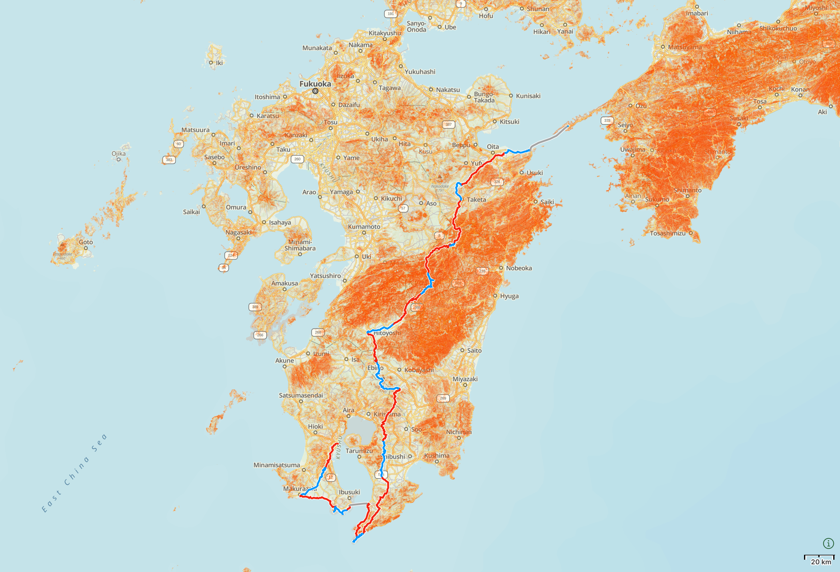
Kyushu: April 13 – May 5, 2017
- Day 1, April 13: Kagoshima City → Kawanabe, Kagoshima
- Day 2, April 14: Kawanabe, Kagoshima → Makurazaki, Kagoshima
- Day 3, April 15: Rest day in Kagoshima City
- Day 4, April 16: Rest day in Kagoshima City
- Day 5, April 17: Makurazaki, Kagoshima → Kaimon, Kagoshima
- Day 6, April 18: Kaimon, Kagoshima → Mount Kaimon → Yamakawa, Kagoshima
- Day 7, April 19: Yamakawa, Kagoshima → Ferry across Kagoshima Bay → Sata, Kagoshima
- Day 8, April 20: Sata, Kagoshima → Cape Sata → Satakori, Kagoshima
- Day 9, April 21: Satakori, Kagoshima → Kanoya, Kagoshima
- Day 10, April 22: Kanoya, Kagoshima → Kihoku, Kagoshima
- Day 11, April 23: Kihoku, Kagoshima → Lake Miike, Miyazaki
- Day 12, April 24: Rest day at Lake Miike
- Day 13, April 25: Lake Miike, Miyazaki → Takachiho-no-mine → Mount Karakuni → Kakutō, Miyazaki
- Day 14, April 26: Kakutō, Miyazaki → Kakutō Pass → Hitoyoshi, Kumamoto
- Day 15, April 27: Hitoyoshi, Kumamoto → Taragi, Kumamoto
- Day 16, April 28: Taragi, Kumamoto → Shiiba, Miyazaki
- Day 17, April 29: Shiiba, Miyazaki
- Day 18, April 30: Shiiba, Miyazaki → Takachiho, Miyazaki
- Day 19, May 1: Takachiho, Miyazaki
- Day 20, May 2: Takachiho, Miyazaki → Mount Sobo → Taketa, Ōita
- Day 21, May 3: Taketa, Ōita → Kamitsutsumi, Ōita
- Day 22, May 4: Kamitsutsumi, Ōita → Ōita City
- Day 23, May 5: Ōita City → Saganoseki, Ōita → Hōyo Strait → Misaki, Ehime
Shikoku: May 6–21, 2017
- Day 24, May 6: Misaki, Ehime → Kameura, Ehime
- Day 25, May 7: Kameura, Ehime → Futami, Ehime
- Day 26, May 8: Futami, Ehime → Matsuyama, Ehime
- Day 27, May 9: Matsuyama, Ehime → Tōon, Ehime
- Day 28, May 10: Namegawa, Ehime → Kuromori Pass → Kasagata, Ehime
- Day 29, May 11: Kasagata, Ehime → Tsuchigoya, Ehime
- Day 30, May 12: Tsuchigoya, Ehime → Mount Ishizuchi → Nagasawa, Kōchi
- Day 31, May 13: Nagasawa, Kōchi → West Ishihara, Kōchi
- Day 32, May 14: West Ishihara, Kōchi → Tosa, Kōchi
- Day 33, May 15: Tosa, Kōchi → Yamajiro, Tokushima
- Day 34, May 16: Yamajiro, Tokushima → Kubo, Tokushima
- Day 35, May 17: Kubo, Tokushima → Mount Tsurugi → Kawai, Tokushima
- Day 36, May 18: Kawai, Tokushima → Kawai Pass → Ishii, Tokushima
- Day 37, May 19: Ishii, Tokushima → Hachiman, Tokushima City
- Day 38, May 20: Rest day in Tokushima City
- Day 39, May 21: Hachiman, Tokushima City → Naruto, Tokushima → Naruto Whirlpools → Great Naruto Bridge → South Awaji City, Awaji Island, Hyōgo
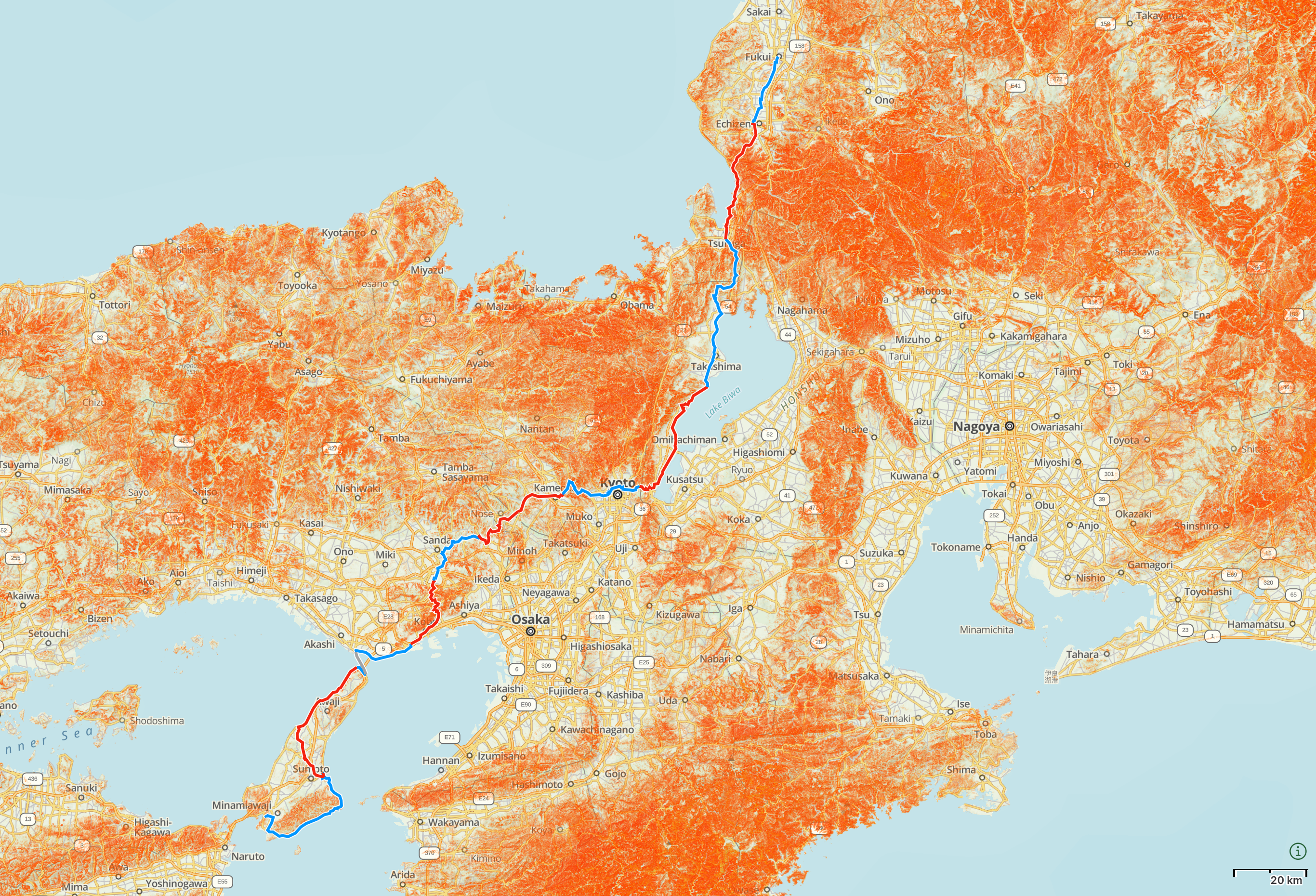
Awaji Island and Kansai (South-Central Honshu): May 22 – June 1, 2017
- Day 40, May 22: South Awaji City, Awaji Island, Hyōgo → Sumoto, Awaji Island, Hyōgo
- Day 41, May 23: Sumoto, Awaji Island, Hyōgo → Esaki Lighthouse, Awaji Island, Hyōgo
- Day 42, May 24: Esaki Lighthouse, Awaji Island, Hyōgo → Akashi Strait → Nagata Ward, Kōbe, Hyōgo
- Day 43, May 25: Nagata Ward, Kōbe, Hyōgo → Kita Ward, Kōbe, Hyōgo
- Day 44, May 26: Kita Ward, Kōbe, Hyōgo → Inagawa, Hyōgo
- Day 45, May 27: Inagawa, Hyōgo → Kameoka, Kyōto
- Day 46, May 28: Kameoka, Kyōto → Jinmyō Pass → Kyōto → Otsu, Shiga
- Day 47, May 29: Otsu, Shiga → Lake Biwa → Shirahige Shrine, Shiga
- Day 48, May 30: Shirahige Shrine, Shiga → Tsuruga, Fukui
- Day 49, May 31: Tsuruga, Fukui → Echizen, Fukui
- Day 50, June 1: Echizen, Fukui → Fukui City
Chūbu (Central Honshu): June 8 – July 3, 2017
- Day 57, June 8: Fukui City
- Day 58, June 9: Fukui City → Eihei-ji → Mount Daibutsuji → Katsuyama, Fukui
- Day 59, June 10: Katsuyama, Fukui → Shiramine, Ishikawa
- Day 60, June 11: Shiramine, Ishikawa → Hakusan → Gomadaira Mountain Shelter, Ishikawa
- Day 61, June 12: Gomadaira Mountain Shelter, Ishikawa → Hakusan Shirakawa-gō White Road → Ogimachi, Shirakawa-gō, Gifu
- Day 62, June 13: Ogimachi, Shirakawa-gō, Gifu → Amou Pass → Hida Furukawa, Gifu
- Day 63, June 14: Hida Furukawa, Gifu → Hida Takayama, Gifu
- Day 64, June 15: Hida Takayama, Gifu → Takane, Gifu
- Day 65, June 16: Takane, Gifu → Mount Ontake → Kaida Plateau, Nagano
- Day 66, June 17: Kaida Plateau, Nagano → Jizō Pass → Kiso Fukushima, Nagano
- Day 67, June 18: Kiso Fukushima, Nagano → Torii Pass → Shiojiri, Nagano
- Day 68, June 19: Shiojiri, Nagano → Shiojiri Pass → Upper Suwa, Nagano
- Day 69, June 20: Upper Suwa, Nagano → Mount Kirigamine → Mochizuki, Nagano
- Day 70, June 21: Mochizuki, Nagano → Karuizawa, Nagano
- Day 71, June 22: Karuizawa, Nagano → Nidoage Pass → Mount Haruna, Gunma
- Day 72, June 23: Mount Haruna, Gunma → Shōwa, Gunma
- Day 73, June 24: Shōwa, Gunma → Katashina, Gunma
- Day 74, June 25: Katashina, Gunma → Konsei Tunnel → Lake Chūzenji, Tochigi
- Day 75, June 26: Lake Chūzenji, Tochigi → Mount Nantai → Nikkō, Tochigi
- Day 76, June 27: Nikkō, Tochigi
- Day 77, June 28: Nikkō, Tochigi → Ujiie, Tochigi
- Day 78, June 29: Ujiie, Tochigi → Nakagawa, Tochigi
- Day 79, June 30: Nakagawa, Tochigi → Hanawa, Fukushima
- Day 80, July 1: Hanawa, Fukushima → Tōno, Fukushima
- Day 81, July 2: Tōno, Fukushima → Iwaki, Fukushima
- Day 82, July 3: Iwaki, Fukushima → Shioyazaki Lighthouse, Fukushima
Tōhoku (Northeast Honshu): July 4–24, 2017
- Day 83, July 4: Shioyazaki Lighthouse, Fukushima → Naraha, Fukushima
- Day 84, July 5: Naraha, Fukushima → Fukushima nuclear exclusion zone → Namie, Fukushima → Minamisōma, Fukushima
- Day 85, July 6: Minamisōma, Fukushima → Marumori, Miyagi
- Day 86, July 7: Marumori, Miyagi → Zaō, Miyagi
- Day 87, July 8: Zaō, Miyagi → Mount Zaō → Zaō Hot Spring, Yamagata
- Day 88, July 9: Zaō Hot Spring, Yamagata → Yamagata City → Tendō, Yamagata
- Day 89, July 10: Tendō, Yamagata → Tomiyama, Yamagata
- Day 90, July 11: Tomiyama, Yamagata → Natagiri Pass → Mogami, Yamagata → Hanatate Pass → Onikōbe, Miyagi
- Day 91, July 12: Onikōbe, Miyagi → Yunohama Pass → Hanayama Pass → Minase, Akita
- Day 92, July 13: Minase, Akita → Sannai, Akita
- Day 93, July 14: Sannai, Akita → Sawauchi, Iwate
- Day 94, July 15: Sawauchi, Iwate → Shizukuishi, Iwate
- Day 95, July 16: Shizukuishi, Iwate → Omisaka Trailhead, Mount Iwate
- Day 96, July 17: Omisaka Trailhead, Mount Iwate → Mount Iwate → Appi Plateau, Iwate
- Day 97, July 18: Appi Plateau, Iwate → Jōbōji, Iwate
- Day 98, July 19: Jōbōji, Iwate → Takko, Aomori → Hakka Pass → Lake Towada, Akita
- Day 99, July 20: Lake Towada, Akita → Oirase Gorge → Towada, Aomori
- Day 100, July 21: Towada, Aomori → Noheji, Aomori
- Day 101, July 22: Noheji, Aomori → Mutsu Bay → Mutsu, Aomori
- Day 102, July 23: Mutsu, Aomori → Lake Usori → Yagen Hot Spring, Aomori
- Day 103, July 24: Yagen Hot Spring, Aomori → Ōma, Aomori → Tsugaru Strait → Hakodate, Hokkaido
Hokkaido: July 25 – August 21, 2017
- Day 104, July 25: Rest day in Hakodate
- Day 105, July 26: Hakodate → Lake Ōnuma
- Day 106, July 27: Lake Ōnuma → Otoshibe
- Day 107, July 28: Otoshibe → Kuroiwa Station
- Day 108, July 29: Kuroiwa Station → Oshamambe → Rebunge, Toyoura
- Day 109, July 30: Rebunge, Toyoura → Makkari
- Day 110, July 31: Makkari → Mount Shiribeshi → Nakayama Pass
- Day 111, August 1: Nakayama Pass → Sapporo
- Day 112, August 2: Rest day in Sapporo
- Day 113, August 3: Sapporo → Nopporo, Ebetsu
- Day 114, August 4: Nopporo, Ebetsu → Kuriyama
- Day 115, August 5: Kuriyama → ⛏ Yūbari → Kaede, Yūbari
- Day 116, August 6: Kaede, Yūbari → Niniu, Shimukappu
- Day 117, August 7: Niniu, Shimukappu → Shimukappu
- Day 118, August 8: Shimukappu → Ochiai, South Furano
- Day 119, August 9: Ochiai, South Furano → Karikachi Pass → Shintoku
- Day 120, August 10: Shintoku → Shihoro
- Day 121, August 11: Shihoro → Ashoro
- Day 122, August 12: Ashoro → Upper Rawan
- Day 123, August 13: Upper Rawan → Lake Onnetō → Mount Meakan → Lake Akan Hot Spring
- Day 124, August 14: Lake Akan Hot Spring → Tsurumi Pass → Tsurui
- Day 125, August 15: Tsurui → Kushiro Shitsugen National Park → Kushiro
- Day 126, August 16: Kushiro → Konbumori
- Day 127, August 17: Konbumori → Akkeshi
- Day 128, August 18: Akkeshi → Kiritappu, Hamanaka
- Day 129, August 19: Kiritappu, Hamanaka → Hattaushi Station
- Day 130, August 20: Hattaushi Station → Lake Furen → Nemuro
- Day 131, August 21: Nemuro → Cape Nosappu → Nemuro Station
Further reading
Alan Booth’s The Roads to Sata, the exquisite account of a similar walk undertaken four decades previously, in the summer and autumn of 1977, served as the main inspiration for my journey — even if our paths barely crossed. He largely followed the coast, stayed in country inns, and walked from north to south, while I preferred the mountains, slept in sheds, shrines, and parks, and walked from south to east.
A more explicit connection between Booth’s work and mine is The Wilds of Shikoku, my first book, in which I wrote about following in the exact footsteps of another of his journeys, a five hundred kilometer walk across Shikoku — Booth’s in May and June 1983, mine in January and February 2019. Booth’s account of his own journey, “Roads Out of Time”, was published in the anthology This Great Stage of Fools, and both his account and mine were edited by Timothy Harris.
I also drew on Fukada Kyūya’s One Hundred Mountains of Japan, this odd mixture of baedeker and literary nonfiction from 1964, which is as much about the etymology of Japanese geographical names as about the practical aspects of climbing Japan’s mountains. Along the way from one end of Japan to the other I climbed or traversed 12 of Fukada’s one hundred mountains, and made an aborted attempt on a 13th, the volcano Ontake.
Notes and acknowledgments
I do not know the names of most of the people who helped me on this journey of four months. They are those who maintain the marvelous infrastructure of this mountainous and seismically unstable archipelago, the roads, tunnels, and footpaths without which I could barely have walked a kilometer, let alone 4,100. Dozens of individuals I met went out of their way to help me, a stranger from a country most of them had never heard of, without any thought of reward.
John Ebert, Gyökös Lajos, Ikematsu-Papp Gabriella, Kuroiwa Naoki, Nagate Satomi 長手里美, Nishimoto Kyōko 西本京子, Ōhashi Aki 大橋亜紀, Orosz Gábor, Michael Sileny, Stephen Wheeler, Yoshihara Hitoshi 吉原均, Yoshihara Mihály Aoi 吉原ミハイ青衣, and Yoshihara-Horváth Hanga provided invaluable assistance while I was in Japan.
Japanese words, geographical locations, and personal names are transcribed into English using the Modified Hepburn romanization. Japanese names are written in the Japanese order, the family name first and the given name second. With the exception of the names of Tokyo, Osaka, Hokkaido, Honshu, and Kyushu, spelled in the international style, long vowels are marked with macrons (ō, ū).
Geographical names are based on data from Google Maps, OpenStreetMap, the Geospatial Information Authority of Japan, and other sources. Google Translate and Renzo Japanese were used to clarify transliterations.
Maps are plotted in Gaia GPS, using data from OpenStreetMap. Overview maps on this index page are displayed on Gaia GPS’s Gaia Topo, overlayed with slopes data from the Geospatial Information Authority of Japan, while day-by-day maps are displayed on Thunderforest Landscape.
Special thanks to Natalie Kallay, my wife, who has always encouraged and supported my wanderings.
Last update: March 5, 2025
The ferries were across Kagoshima Bay (Day 7), the Hōyo Strait (Day 23), the Akashi Strait (Day 42), and the Tsugaru Strait (Day 103). The tolls roads were a section of the Kōbe-Awaji-Naruto Expressway across the Great Naruto Bridge (Day 39), and most of the Hakusan Shirakawa-gō White Road (Day 61). The nuclear exclusion zone was the one around the Fukushima Daiichi Nuclear Power Plant (Day 84). These sections are explained in footnotes on the day-to-day pages.↩︎
It took me 131 days to reach Cape Nosappu from Kagoshima, and I spent 119 of these days walking. The remaining 12 were split between scattered rest days and a six-day trip to Korea in early June (to renew my Japanese entry permit). I carried an iPhone, which logs walking distance automatically, and I also plotted my path separately on OpenStreetMap. From these two sources I estimate that I walked around 4,100 kilometers and gained about 120,000 meters of elevation.↩︎